mobile View, to the German Version tap the flag


- Alderney, with the neighbouring islands of Herm, Sark, Guernsey and Jethou, constitutes the administrative bailiwick/district of Guernsey, an autonomous and by the British crown adminstrated territory
- one of the Channel Islands (Norman Islands)
- own name in French: Aurigny
• Flags
• Meaning/Origin of the Flag
• Coat of Arms
• Meaning/Origin of the Coat of Arms
• Maps
• Numbers and Facts
• History
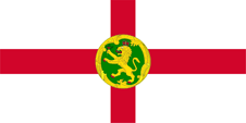
since 1906,
Flag of Alderney,
ratio = 1:2,
Source, by:
Wikipedia (EN),
Denelson83,
CC BY-SA 4.0, via Wikimedia Commons


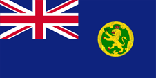
since 2007,
Flag of the government (state flag),
ratio = 1:2,
Source, by:
Wikipedia (EN),
World Statesmen


Alderney uses the flag of England, the red St. George's cross on white background, with the depction of the scutcheon of the island laid out in the centre. It is round with a golden border and shows a crowned, soaring, golden lion with red claws on green ground, holding a plant in his paw. In 2007, a Blue Ensign was also introduced. United Kingdom introduced a flag system in 1864 in which:
• war ships fly the "White Ensign" (naval flag), a white flag often with an uninterrupted red St. George's-Cross and with the Union Jack in the upper staff quadrant of the flag,
• merchant ships fly a "Red Ensign" (also named "Civil Ensign" => civil flag, the real merchant flag), a red flag with the Union Jack in the upper staff quadrant of the flag, and
• governmental ships fly the "Blue Ensign" (flag for the use by the gouvernment => the actual state flag), a blue flag with the Union Jack in the upper staff quadrant of the flag.
Since 1865, ships of regional or colonial governments, as well of offices and authorities, were allowed to use a Blue Ensign with a badge in the flying end.
Source:
Wikipedia (EN),
World Statesmen,
Die Welt der Flaggen,
Volker Preuß
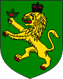
Coat of arms of Alderney,
Source, by:
Wikipedia (EN),
Denelson83,
CC BY-SA 4.0, via Wikimedia Commons
The coat of arms of Alderney shows a crowned, soaring, golden lion with red claws on green ground, holding a plant in his paw.
Source: Wikipedia (EN)
Location:
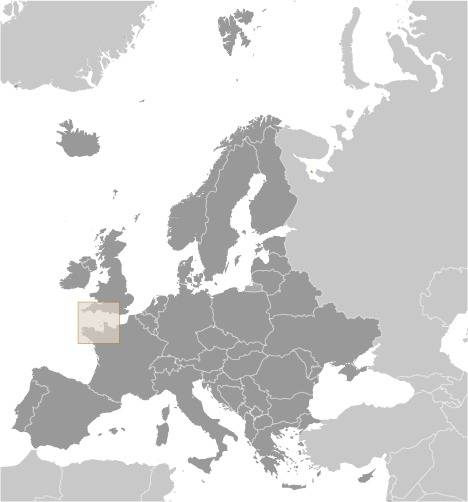
Source: CIA World Factbook
Map of the country:
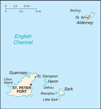
Source: CIA World Factbook
Map of the Channel Islands:
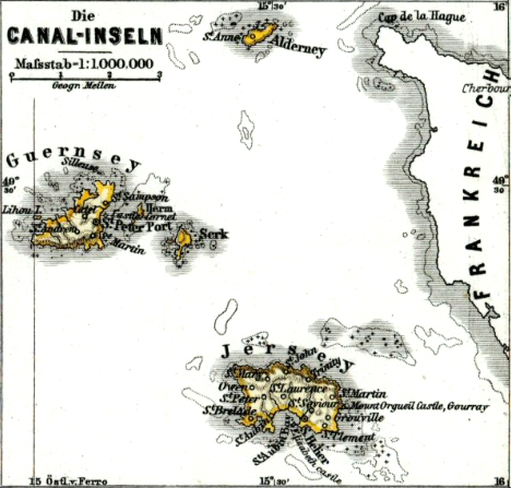
Source: Hand-Atlas für die Geschichte des Mittelalters und die neueren Zeit, von Spruner und Menke
In the north Alderney, in the south Jersey, in the west Guernsey, eastern of it Herm and Sark.
Area: 3 square miles
Inhabitants: 2.019 (2018)
Density of Population: 654 inh./sq.mi.
Capital: Saint Anne, 2.000 inh.
official Language: English
Currencies: 1 Alderney Pound (£) = 100 Pence, 1 Pound Sterling (£) = 100 Pence
Time Zone: Greenwich Meantime = CET – 1 h
Source:
Wikipedia (DE)
ca. 600 B.C. · Celtic settlement
56 B.C. · to the Roman Empire
511 · to the Frankish Empire
843 · to the West Frankish Empire
880 · to the Kingdom of France
933 · to the Duchy of Normandy
1066 · William I. (Duke of the Normandy) gets crowned to the King of England, therewith come the Channel Islands nominally to the English crown
1106 · King Henry I. of England (son of William I.) occupies the Channel Islands, separates them therewith from the Duchy of Normandy, and binds them on England
1940–1945 · occupied by the German Empire
Translator of the English text: Joachim Nuthack
Source:
Atlas zur Geschichte,
Wikipedia (DE),
Discovery '97