mobile View, to the German Version tap the flag


Switzerland today consists of 26 cantons. The Swiss Federal Constitution referres in Article 1 the cantons as "sovereign". The main responsibilities of the cantons are today in the areas of education, justice (Jurisdiction and Procedure Law), police, health, welfare, road construction and municipal law, but also in the execution of federal laws by the cantonal administration.
Source: © Bertelsmann Lexikon Verlag, Gütersloh 1996, from: Bertelsmann Discovery '97, © Bertelsmann Electronic Publishing GmbH, München 1996
The Canton of Appenzell has consisted of the half-cantons Appenzell-Innerrhoden and Appenzell-Ausserrhoden since 1597. The Canton of Unterwalden has consisted of the half-cantons of Nidwalden and Obwalden since 1999.

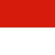
Official Language: German
Main place (capital): Aarau
Area: 542 sq.mi.
Inhabitants: 703.086 (2021)
Density of Population: 1.297 inh./sq.mi.
Joining the Confederation: 1803
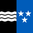
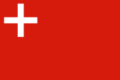
Flag of the Canton,
ratio = 1:1,
Source, by: Wikipedia (D)


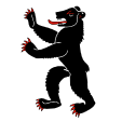
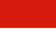
Cantonal colours (Standesfarben),
ratio = 2:3,
Source, by: Das farbige Flaggenlexikon

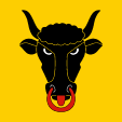
Official Language: German
Main place (capital): Appenzell
Area: 67 sq.mi.
Inhabitants: 16.360 (2021)
Density of Population: 245 inh./sq.mi.
Joining the Confederation: 1513
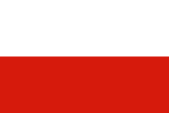
Flag of the Canton,
ratio = 1:1,
Source, by: Wikipedia (D)

Cantonal colours (Standesfarben),
ratio = 2:3,
Source, by: Das farbige Flaggenlexikon
Official Language: German
Main place (capital): Herisau
Area: 94 sq.mi.
Inhabitants: 55.585 (2021)
Density of Population: 592 inh./sq.mi.
Joining the Confederation: 1513

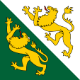
Flag of the Canton,
ratio = 1:1,
Source, by: Wikipedia (D)

Cantonal colours (Standesfarben),
ratio = 2:3,
Source, by: Das farbige Flaggenlexikon
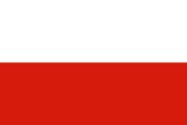
Official Language: German
Main place (capital): Liestal
Area: 200 sq.mi.
Inhabitants: 292.817 (2021)
Density of Population: 1.464 inh./sq.mi.
Joining the Confederation: 1501

Flag of the Canton,
ratio = 1:1,
Source, by: Wikipedia (D)
Cantonal colours (Standesfarben),
ratio = 2:3,
Source, by: Das farbige Flaggenlexikon
Official Language: German
Main place (capital): Basel
Area: 14 sq.mi.
Inhabitants: 196.036 (2021)
Density of Population: 13.723 inh./sq.mi.
Joining the Confederation: 1501

Flag of the Canton,
ratio = 1:1,
Source, by: Wikipedia (D)

Cantonal colours (Standesfarben),
ratio = 2:3,
Source, by: Das farbige Flaggenlexikon
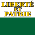
Official Languages: German (84 %), French (8 %)
Main place (capital): Bern
Area: 2.001 sq.mi.
Inhabitants: 1.047.473 (2021)
Density of Population: 4 inh./sq.mi.
Joining the Confederation: 1353
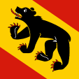
Flag of the Canton,
ratio = 1:1,
Source, by: Wikipedia (D)

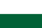
Cantonal colours (Standesfarben),
ratio = 2:3,
Source, by: Das farbige Flaggenlexikon
(German: Freiburg)
Official Languages: German (27 %), French (69 %)
Main place (capital): Freiburg
Area: 646 sq.mi.
Inhabitants: 329.809 (2021)
Density of Population: 511 inh./sq.mi.
Joining the Confederation: 1481

Flag of the Canton,
ratio = 1:1,
Source, by: Wikipedia (D)

Cantonal colours (Standesfarben),
ratio = 2:3,
Source, by: Das farbige Flaggenlexikon
(French: Genève, German: Genf)
Official Language: French
Main place (capital): Genf
Area: 264 sq.mi.
Inhabitants: 509.448 (2021)
Density of Population: 156 inh./sq.mi.
Joining the Confederation: 1815
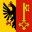
Flag of the Canton,
ratio = 1:1,
Source, by: Wikipedia (D)

Cantonal colours (Standesfarben),
ratio = 2:3,
Source, by: Das farbige Flaggenlexikon
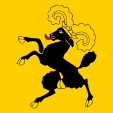
Official Language: German
Main place (capital): Glarus
Area: 264 sq.mi.
Inhabitants: 41.190 (2021)
Density of Population: 156 inh./sq.mi.
Joining the Confederation: 1352
Flag of the Canton,
ratio = 1:1,
Source, by: Wikipedia (D)
Cantonal colours (Standesfarben),
ratio = 2:3,
Source, by: Das farbige Flaggenlexikon
(Deutsch: Graubünden, Rhaeto-Roman: Grischun, Italian: Grigion)
Official Languages: German (75 %), Rhaeto-Roman (15 %), Italian (13 %)
Main place (capital): Chur
Area: 2.743 sq.mi.
Inhabitants: 201.376 (2021)
Density of Population: 73 inh./sq.mi.
Joining the Confederation: 1803
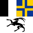
Flag of the Canton,
ratio = 1:1,
Source, by: Wikipedia (D)

Cantonal colours (Standesfarben),
ratio = 2:3,
Source, by: Das farbige Flaggenlexikon
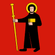
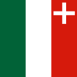
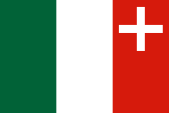
Official Language: French
Main place (capital): Delémont
Area: 324 sq.mi.
Inhabitants: 73.798 (2021)
Density of Population: 228 inh./sq.mi.
Joining the Confederation: 1979

Flag of the Canton,
ratio = 1:1,
Source, by: Wikipedia (D)
Cantonal colours (Standesfarben),
ratio = 2:3,
Source, by: Wikipedia (D)
(German: Luzern, French: Lucerne, Italian: Lucerna)
Official Language: German
Main place (capital): Luzern
Area: 577 sq.mi.
Inhabitants: 420.326 (2021)
Density of Population: 729 inh./sq.mi.
Joining the Confederation: 1332

Flag of the Canton,
ratio = 1:1,
Source, by: Wikipedia (D)

Cantonal colours (Standesfarben),
ratio = 2:3,
Source, by: Das farbige Flaggenlexikon
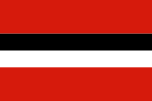
(German: Neuenburg)
Official Language: French
Main place (capital): Neuenburg
Area: 310 sq.mi.
Inhabitants: 176.166 (2021)
Density of Population: 569 inh./sq.mi.
Joining the Confederation: 1815
Flag of the Canton,
ratio = 1:1,
Source, by: Wikipedia (D)
Cantonal colours (Standesfarben),
ratio = 2:3,
Source, by: Das farbige Flaggenlexikon
Official Language: German
Main place (capital): Stans
Area: 107 sq.mi.
Inhabitants: 43.894 (2021)
Density of Population: 412 inh./sq.mi.
Joining the Confederation: 1291
Flag of the Canton,
ratio = 1:1,
Source, by: Wikipedia (D)

Cantonal colours (Standesfarben),
ratio = 2:3,
Source, by: Wikipedia (D)
Official Language: German
Main place (capital): Sarnen
Area: 190 sq.mi.
Inhabitants: 38.435 (2021)
Density of Population: 203inh./sq.mi.
Joining the Confederation: 1291
Flag of the Canton,
ratio = 1:1,
Source, by: Wikipedia (D)

Cantonal colours (Standesfarben),
ratio = 2:3,
Source, by: Wikipedia (D)
(French: Saint-Gall, Italian: San Gallo)
Official Language: German
Main place (capital): St. Gallen
Area: 783 sq.mi.
Inhabitants: 519.245 (2021)
Density of Population: 663 inh./sq.mi.
Joining the Confederation: 1803
Flag of the Canton,
ratio = 1:1,
Source, by: Wikipedia (D)

Cantonal colours (Standesfarben),
ratio = 2:3,
Source, by: Das farbige Flaggenlexikon

Official Language: German
Main place (capital): Schaffhausen
Area: 115 sq.mi.
Inhabitants: 83.995 (2021)
Density of Population: 730 inh./sq.mi.
Joining the Confederation: 1501
Flag of the Canton,
ratio = 1:1,
Source, by: Wikipedia (D)

Cantonal colours (Standesfarben),
ratio = 2:3,
Source, by: Das farbige Flaggenlexikon
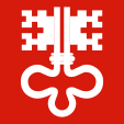
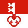
Official Language: German
Main place (capital): Schwyz
Area: 351 sq.mi.
Inhabitants: 163.689 (2021)
Density of Population: 467 inh./sq.mi.
Joining the Confederation: 1291
Flag of the Canton,
ratio = 1:1,
Source, by: Wikipedia (D)
Cantonal colours (Standesfarben),
ratio = 2:3,
Source, by: Das farbige Flaggenlexikon
Official Language: German
Main place (capital): Solothurn
Area: 305 sq.mi.
Inhabitants: 280.245 (2021)
Density of Population: 919 inh./sq.mi.
Joining the Confederation: 1481
Flag of the Canton,
ratio = 1:1,
Source, by: Wikipedia (D)

Cantonal colours (Standesfarben),
ratio = 2:3,
Source, by: Das farbige Flaggenlexikon
(Italian: Ticino, French: Tessin, German: Tessin)
Official Language: Italian
Main place (capital): Bellinzona
Area: 1.086 sq.mi.
Inhabitants: 352.181 (2021)
Density of Population: 324 inh./sq.mi.
Joining the Confederation: 1803

Flag of the Canton,
ratio = 1:1,
Source, by: Wikipedia (D)

Cantonal colours (Standesfarben),
ratio = 2:3,
Source, by: Das farbige Flaggenlexikon
Official Language: German
Main place (capital): Frauenfeld
Area: 384 sq.mi.
Inhabitants: 285.964 (2021)
Density of Population: 745 inh./sq.mi.
Joining the Confederation: 1803
Flag of the Canton,
ratio = 1:1,
Source, by: Wikipedia (D)
Cantonal colours (Standesfarben),
ratio = 2:3,
Source, by: Das farbige Flaggenlexikon
Former canton, existing between 1291 and 1798 and 1815 and 1999. In 1999 the Canton of Unterwalden was split into the Cantons of Nidwalden and Obwalden.
Official Language: German
Main place (capital): Sarnen
Joining the Confederation: 1291
Flag of the Canton,
ratio = 1:1,
Source, by: Wikipedia (D)

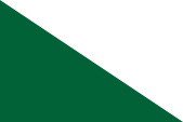
Cantonal colours (Standesfarben),
ratio = 2:3,
Source, by: Das farbige Flaggenlexikon
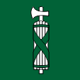
Official Language: German
Main place (capital): Altdorf
Area: 416 sq.mi.
Inhabitants: 37.047 (2021)
Density of Population: 89 inh./sq.mi.
Joining the Confederation: 1291
Flag of the Canton,
ratio = 1:1,
Source, by: Wikipedia (D)

Cantonal colours (Standesfarben),
ratio = 2:3,
Source, by: Das farbige Flaggenlexikon
(French: Vaud; German: Waadt)
Official Language: French
Main place (capital): Lausanne
Area: 1.240 sq.mi.
Inhabitants: 822.968 (2021)
Density of Population: 664 inh./sq.mi.
Joining the Confederation: 1803
Flag of the Canton,
ratio = 1:1,
Source, by: Wikipedia (D)
Cantonal colours (Standesfarben),
ratio = 2:3,
Source, by: Das farbige Flaggenlexikon
(French: Valais, Italian: Vallese)
Official Languages: French (63 %), German (28 %)
Main place (capital): Sitten (Sion)
Area: 2.017 sq.mi.
Inhabitants: 353.209 (2021)
Density of Population: 175 inh./sq.mi.
Joining the Confederation: 1815
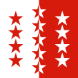
Flag of the Canton,
ratio = 1:1,
Source, by: Wikipedia (D)
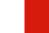
Cantonal colours (Standesfarben),
ratio = 2:3,
Source, by: Das farbige Flaggenlexikon
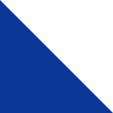
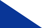
Official Language: German
Main place (capital): Zug
Area: 92 sq.mi.
Inhabitants: 129.787 (2021)
Density of Population: 1.406 inh./sq.mi.
Joining the Confederation: 1352

Flag of the Canton,
ratio = 1:1,
Source, by: Wikipedia (D)

Cantonal colours (Standesfarben),
ratio = 2:3,
Source, by: Das farbige Flaggenlexikon
(German: Zürich)
Official Language: German
Main place (capital): Zürich
Area: 668 sq.mi.
Inhabitants: 1.564.662 (2021)
Density of Population: 2.344 inh./sq.mi.
Joining the Confederation: 1351
Flag of the Canton,
ratio = 1:1,
Source, by: Wikipedia (D)
Cantonal colours (Standesfarben),
ratio = 2:3,
Source, by: Das farbige Flaggenlexikon
Kindly supported by: Fabio Vassalli (CH)