mobile View, to the German Version tap the flag


- The Netherlands is divided into twelve provinces
• Friesland (Fryslân)
• Groningen
• Drenthe
• Gelderland
• Overijssel
• Flevoland (East Polder)
• Utrecht
• North Holland
• South Holland
• Zealand
• North Brabant
• Limburg
• State-Flanders
Map: Volker Preuß

(Frisian: Fryslân)
Area: 1.294 square miles
Inhabitants: 644.000 (2008)
Capital: Leeuwarden
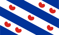
Flag of the Province of Friesland


All of Friesland (West Friesland, Groningen and East Friesland) existed in a long time outside the feudal system and the individual communities had been subordinated directly to the German emperor. This stayed like that, as West Friesland in 1524 an Groningen in 1536 became an Habsburg possession. Friesland belonged from 1579 to the "Union of Utrecht" and from 1581 to the "Republic of the United Netherlands". The flag of the Province of Friesland was adopted in 1957 and goes back to a coat of arms of the 15th century. The white and blue stripes and the lily pads represent the municipalities of the province.
Source:
Wikipedia (D),
Flaggen Enzyklopädie,
Atlas zur Geschichte,
Discovery '97
Area: 1.006 square miles
Inhabitants: 572.000 (2008)
Capital: Groningen
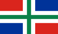
Flag of the Province of Groningen
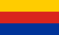
Groningen initially belonged to Frisia, however, it became in 1536 an Habsburg possession belonged from 1579 to the "Union of Utrecht" and from 1581 to the "Republic of the United Netherlands". The flag of the Province of Groningen was adopted in 1950, combining the colors of the City of Groningen (green and white) with the colors of Ommeland (red, white and blue).
Source: Wikipedia (D),
Flaggen Enzyklopädie,
Atlas zur Geschichte,
Discovery '97
Area: 1.037 square miles
Inhabitants: 489.000 (2008)
Capital: Assen

Flag of the Province of Drenthe
Drenthe belonged initially to 1528 to the Diocese of Utrecht, became in 1536 an Habsburg possession as a county, belonged from 1579 to the "Union of Utrecht" and from 1581 to the "Republic of the United Netherlands". The flag of the Province of Drenthe was adopted in 1950. The colors red and white go back to the Diocese of Utrecht, to which this province formerly belonged. The stylized black castle is Coevorden Castle, where in 1227 started a revolt against the Bishop of Utrecht. The six stars represent the historic six court sites in the region.
Source:
Wikipedia (D),
Flaggen Enzyklopädie,
Atlas zur Geschichte,
Discovery '97
Area: 1.935 square miles
Inhabitants: 1.988.000 (2008)
Capital: Arnheim

Flag of the Province of Gelderland
Gelderland was from 1339 a part of the Duchy of Geldern, which in 1383 was transferred to the Duke of Julich. It became in 1543 an Habsburg possession, belonged from 1579 to the "Union of Utrecht" and from 1581 to the "Republic of the United Netherlands". The flag of the Province of Gelderland was adopted in 1953. Its colors go back to the crest of the Duchy of Geldern (golden lion on blue) and the Duchy of Julich (black lion on gold). Their colors had been combined in this flag.
Source: Wikipedia (D),
Flaggen Enzyklopädie,
Atlas zur Geschichte,
Discovery '97
Area: 1.516 square miles
Inhabitants: 1.123.000 (2008)
Capital: Zwolle
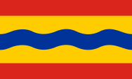
Flag of the Province of Overijssel
Overijssel belonged to the Diocese of Utrecht until 1528, when it became an Habsburg possession. It belonged from 1579 to the "Union of Utrecht" and from 1581 to the "Republic of the United Netherlands". The flag of the Province of Overijssel was adopted in 1948. Its colors go back to the arms of Overijssel. It is the arms of Holland, a red lion on gold, with a corrugated, blue, horizontal bar. In the flag the wave line should represent the river Ijssel.
Source: Wikipedia (D),
Flaggen Enzyklopädie,
Atlas zur Geschichte,
Discovery '97
(also Dutch: Oost-Polder)
Area: 549 square miles
Inhabitants: 381.000 (2008)
Capital: Lelystad
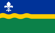
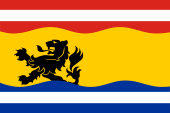
Flag of the Province of Flevoland
Flevoland was created by reclamation of the Ijssel Sea between 1957 and 1968. This should be expressed in the design of the in 1986 introduced flag, through the expiry of the yellow wavy line in the middle into a straight line. Blue stands for water, green for the land and yellow for the rape, which was first cultivated on the dry land. The lily should remember the name of Cornelis Lely, who has planned the land reclamation in the late 19th century has planned.
Source: Wikipedia (D),
Flaggen Enzyklopädie,
Discovery '97
Area: 539 square miles
Inhabitants: 1.206.000 (2008)
Capital: Utrecht
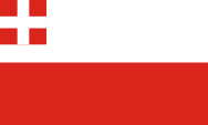
Flag of the Province of Utrecht
The Diocese of Utrecht was founded in 695, until it became an Habsburg possession in 1528. It belonged from 1579 to the "Union of Utrecht" and from 1581 to the "Republic of the United Netherlands". The flag of the Province of Utrecht was adopted in 1948. White and red are the colors of the City of Utrecht. The upper corner of the flag shows the heraldry of the Diocese of Utrecht, to which the province belonged in the past.
Source: Wikipedia (D),
Flaggen Enzyklopädie,
Atlas zur Geschichte,
Discovery '97
(Dutch: Noord-Holland)
Area: 1.030 square miles
Inhabitants: 2.639.000 (2008)
Capital: Haarlem
Flag of the Province of North Holland
The County of Holland belonged from 1299 to Hainault, from 1345 to Wittelsbach and from 1433 to Burgundy. Burgundy came in 1477 as heir to the House of Habsburg. It belonged from 1579 to the "Union of Utrecht" and from 1581 to the "Republic of the United Netherlands". In 1840 the Province of Holland has been divided in North and South Holland. The flag of the Province of North Holland was adopted in 1958. Its colors go back the arms of the County of Holland (red lion on gold) and of West Friesland (golden lion on blue). Its colors were combined in this flag.
Source: Wikipedia (D),
Flaggen Enzyklopädie,
Atlas zur Geschichte,
Discovery '97
(Dutch: Zuid-Holland)
Area: 1.122 square miles
Inhabitants: 3.470.000 (2008)
Capital: Den Haag
Flag of the Province of South Holland
The County of Holland belonged from 1299 to Hainault, from 1345 to Wittelsbach and from 1433 to Burgundy. Burgundy came in 1477 as heir to the House of Habsburg. It belonged from 1579 to the "Union of Utrecht" and from 1581 to the "Republic of the United Netherlands". In 1840 the Province of Holland has been divided in North and South Holland. The flag of the Province of South Holland was adopted in 1986. It shows the image of the coat of arms of the County of Holland, a red lion on gold.
Source: Wikipedia (D),
Flaggen Enzyklopädie,
Atlas zur Geschichte,
Discovery '97
(Dutch: Zeeland)
Area: 691 square miles
Inhabitants: 381.000 (2008)
Capital: Middelburg
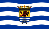
Flag of the Province of Zealand
The County of Zeeland belonged from 1345 to Wittelsbach and from 1433 to Burgundy. Burgundy came in 1477 as heir to the House of Habsburg. Zeeland belonged from 1579 to the "Union of Utrecht" and from 1581 to the "Republic of the United Netherlands". The flag of the Province of Zeeland was adopted in 1949. It shows white and blue wavy lines and in the center the arms of the county from the 15th century. The wavy lines are derived from the lower part of the coat of arms, and should symbolize in the flag the repetitive change of water and land in the landscape of the province. The crest is divided and shows in the upper half of the heraldry of Holland (red lion on gold) and in the lower half six white and blue wavy lines. Above a count's coronet.
Source: Wikipedia (D),
Flaggen Enzyklopädie,
Atlas zur Geschichte,
Discovery '97
(Dutch: Noord-Brabant)
Area: 1.896 square miles
Inhabitants: 2.430.000 (2008)
Capital: 's-Hertogenbosch
Flag of the Province of North Brabant
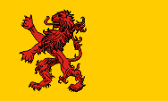
North Brabant – previously also called Generality Lands – is the north of the former Duchy of Brabant, which came to the "Republic of the United Netherlands" not until 1648. The south of Brabant is now placed in Belgium and splited between Flanders and Wallonia. Brabant became in 1355 a possession of Luxembourg, in 1436 a Burgundian possession and came in 1555 as heir to the House of Habsburg. The coat of arms of Brabant shows a red armed golden lion on black, which is used in Belgium on the flags of Brabant. The flag of North Brabant was introduced in 1958, and goes back to a by the Duchy of Brabant used flag of the 17th century.
Source: Wikipedia (D),
Flaggen Enzyklopädie,
Atlas zur Geschichte,
Discovery '97
Area: 837 square miles
Inhabitants: 1.123.000 (2008)
Capital: Maastricht
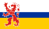
Flag of the Province of Limburg
The former Duchy of Limburg became in 1355 a Luxembourg possession, and in 1406 a Burgundian possession, and came in 1555 as heir to the House of Habsburg. In the Province of Limburg were united – after the Vienna Convention of 1815 – the territory of Limburg with areas of Upper Geldern, Liege and Julich. The coat of arms of Limburg showed a crowned red lion on a white background. The Lion and also white appear on the flag of the province of Limburg, but also a central blue stripe, which symbolizes the river Maas, and a golden stripe, to commemorate the gold in the arms of Julich, Geldern, Hoorn and Valkenburg. The flag was introduced in 1953.
Source: Wikipedia (D),
Flaggen Enzyklopädie,
Atlas zur Geschichte,
Discovery '97
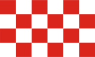
Flag of State-Flanders (Zeeuws-Vlaanderen)

State-Flanders (Dutch: Zeeuws-Vlaanderen) is not a province. It is the part of the territory of the old County of Flanders that is nowadays placed in the Netherlands, in the south of the province of Zealand, in the area of the three municipalities Terneuzen, Sluis and Hulst. Here an own flag is in use since used since 2009. It is the common symbol of the three communities and shows nine stripes in red-white-red-yellow-blue-white-blue in a ratio of 1:1:1:6:1:1:1. In the yellow stripe, moved towards the mast, appears the black lion of Flanders, which also appears in the coat of arms of Hulst. The traditional red reinforcement (tongue and claws) of the lion was deliberately omitted in order to make the lion look "younger, more robust and more dynamic". The upper red stripes come from the flag of Sluis, while the lower blue stripes come from the flag of Terneuzen.
Source: Wikipedia (NL)