mobile View, to the German Version tap the flag


- Landscape in west of the island of Newfoundland
• Flag
• Meaning/Origin of the Flag
• Map
• Numbers and Facts
• History
• Origin of the Country's Name
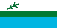
Flag of Labrador,
ratio = 1:2,
Source, by:
Wikipedia (EN)


The flag of Labrador was introduced on 1st of April in 1974 and shows three horizontal stripes in white, green and blue, in a ratio of 2:1:2, and a black spruce branch in the upper canton. The upper white stripe stands for the snow, the narrow, green middle-stripe stands for the fertile land during the short summers, the lower blue stripe stands for the water as a livelihood and the most important transport route. The branch of the black spruce goes back to the French-speaking inhabitants of the country, but stands here for all residents, Innu, Innuit and Europeans. The black spruce is the most common tree in Labrador.
Source:
Wikipedia (EN)
Map to illustrate the Position of the Labrador Peninsula:
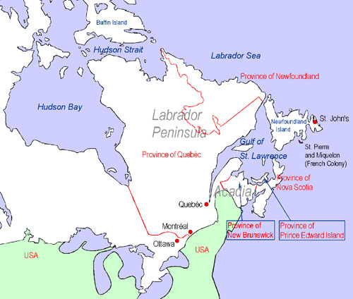
Map: Volker Preuß
Map: Volker Preuß
Area: 540.000 square miles
Inhabitants: 150.000 (2006)
Density of Population: 0,27 inh./sq.mi.
Capital: –
official Language: –
other Languages: English, French
Currency: Canadian currency
Time Zone: GMT – 4 h to - 5 h
Source:
Wikipedia (ES)
ca. 1000 · Normans discover the today's Labrador
1497 · Giovanni Caboto (John Cabot), an Italian seafarer in the services of England discovers Labrador, Newfoundland and Cape Breton
16th cent. · England, Portugal and Spain exercise fishing rights and establish momentaryly fishery bases, the Portugese give the peninsula its name
1670 · English furriers establish the Hudson's Bay Company (HBC), the HBC colonizes in the afteryears whole Canada between New France, the Rocky Mountains, Labrador and the northern rand of the Hudson Bay
1771 · first settlement by Europeans
1869 · the Hudson's Bay Company (HBC) cedes all their territorial rights and prerogatives to the British Dominion of Canada
1895 · establishment of the Ungava Territory on the Labrador Peninsula
1912 · the Ungava Territory becomes annexed to Québec
1927 · Newfoundland gets enlarged westward by annexion of parts of the now to Quebéc belonging former Ungava Territory (Labrador Peninsula)
Source:
Atlas zur Geschichte,
Wikipedia (D),
Discovery '97
The name of the landscape goes back to the Potugiese navigator João Vaz Corte-Real, who called the country "Terra dos lavradores " for reasons that are today not comprehensible no more. That name is to translate as: "Land of the peasants".
Source: Handbuch der geographischen Namen