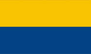
Official flag,
ratio = 3:5


The flag of Upper Silesia shows two parallel stripes in gold and blue. The colours have their roots in the coat of arms of Upper Silesia.
From 1875, the provinces of Prussia could largely operate in self-governing. There was a provincial parliament and a provincial government (Provincial Committee). Each province had its own colors (Landesfarben), which were also used as flag, and they had also their own coat of arms. If the provincial governments put for official purposes (official flag) their coats of arms on a flag with the provincial colors is not handed down beyond doubt and not for all provinces.
Another incident for the flag was the seizure of power by the National Socialists in the German Empire in 1933. All official non-swastika flags, that refered to federalism, regional references or the old German Empire were abolished between 1933 and 1935. For the National Socialists, the federal structure of the German Empire, its historically grown countries, was considered as outdated, as relics of a past to be overcome. In this sense, several laws were enacted, on 31st of March in 1933 the 'Provisional Law for the phasing of the countries with the Empire', on 7th of April 1933 the 'Second Law for the phasing of the countries with the Empire' and finally, on 30th January in 1934 the 'Law on the rebuilding of the empire'. Thus, the federal structure of the German Empire was replaced by the gau-structure of the NSDAP, the countries became meaningless. From now on, offices and authorities had to use the swastika flag as official flag, until September 15th in 1935, when by the flag-law was legislated a new created official flag for all the offices and authorities of the empire. The prime ministers of the countries, which latest in 1933 all came from the NSDAP – now mostly called Reichsstatthalter (maybe translated as 'governor') – however remained in office until 1945. This was then also applied on the provinces of the state of Prussia. Their sovereign duties were taken over by the Gau structure of the NSDAP, which sometimes coincided with the borders of the provinces and sometimes they were new created. The respective provincial flags disappeared. The corresponding country colours continued, with restrictions, but definitly not in the form of flags. They were used, for example, occasionally on uniforms of the SA or in some ranks of the Hitler Youth in the breast cord.
After the war, the administration within the German Empire was rebuilt, but locally, following the structure of the countries. These have been partly old countries, and some new countries were created. Sometimes they bethought the old country colours and reactivated them – or they created new ones – for limited sovereign duties, which were under the control of the Allies. However, the eastern parts of Prussia were occupied by Soviet troops from 1944, and most of them came under Polish or Russian administration. The process described above did not come into being, the German population was forcibly expelled and the old regional flags no longer played a role.
Source: 1) Wikipedia (D), 2)
Wikipedia (D),
Volker Preuß,
Jürgen Kaltschmitt,
Uniform-Fibel
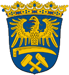
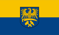
cCoat of arms of Oberschlesien,
Source, by: Wikipedia (D)
The coat of arms of Upper Silesia was created in 1926. It shows on a blue shield an half golden Silesian eagle above a golden scythe and crossed golden hammer and mallet. The golden eagle on blue goes back to the coat of arms of the Duchy of Oppeln, that was used until the extinction of the Piast dukes, however, the eagle beared there a crown. The scythe stands for agriculture and tools stand for the mining industry, the main industries in the country.
Source:
Wikipedia (D),
Volker Preuß,
Jürgen Kaltschmitt
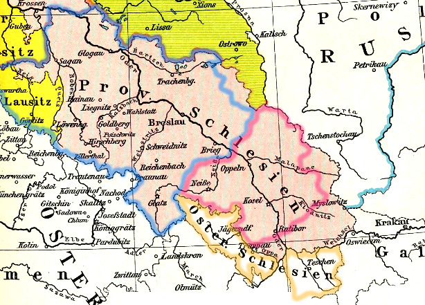
Source:
F. W. Putzgers Historischer Schul-Atlas, modyfied by: Volker Preuß
The historical map shows Prussian Silesia between 1806 and 1815 as bright red area. The yellow areas in the Northeast have been ceded by Saxony to Prussia in 1815 and became connected to Silesia. Austrian Silesia (1742-1918) appears in a dark yellow outline. In the year 1919 Prussian Silesia became divided into two provinces, Upper Silesia (bright red outline) and Lower Silesia (bright blue outline).
Area: 3.746 square mile (1925)
Inhabitants: 1.379.000 (1925)
Density of Population: 368 inh./sq.mi. (1925)
Capital: Oppeln, 41.500 inh. (1925)
Source: www.gonschior.de
1919 · the silesian Governmental District of Oppeln get declared to the Province of Upper Silesia
1920 · ceding of the territories of Troppau and West Teshen to the Czechoslovakia, and of East Teshen to Poland
1922 · ceding of East Upper Silesia to Poland, and of the Hultschin Land (Hlučín Region) to Czechoslovakia
1938 · unification of the Provinces of Upper Silesia and Lower Silesia to the Province of Silesia, re-affiliation of the Hultschin Land (Hlučín Region)
1941 · the Governmental Districts Oppeln/Kattowitz resp. Breslau/Liegnitz get declared to the Provinces Upper Silesia and Lower Silesia
1945 · soviet capture and Polish occupation of Upper Sielsia, expulsion of 1 million German inhabitants out of the Polish occupyed territories, annexation of the Olsa Region and the Hultshin Land by the Czechoslovakia
look furthermore: Silesia
Source:
Wikipedia (D),
Schwarzbuch der Vertreibung
The name of the country goes back to the Vandal tribe of the Silings, who settled here in the second and third century. Also the Sleza River (German: Lohe) – an affluent of the Oder River – counts as source of the name of the country Silesia.
Source: Handbuch der geographischen Namen


Preußische Allgemeine Zeitung
Die Fundgrube für Geschichtsbegeisterte. Mit sehr großem kostenlosen Archiv mit den kompletten Ausgaben dieser Zeitung mit sehr interessanten Artikeln über die preußische Geschichte.