mobile View, to the German Version tap the flag


- former homeland (Bantustan) and autonomous national state in the Republic of South Africa
• Flag
• Map
• Numbers and Facts
• History
• Origin of the Country's Name
KaNgwane was the only homeland not to have its own flag.

Source: Wikipedia (D)
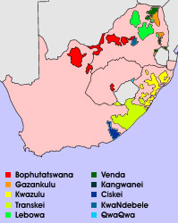
for a big map: click here
(Source: Library of Congress)
Area: 1.200 square miles
Inhabitants: 597.783 (1992), mostly Swasi
Density of Population: 516 inh./sq.mi.
Capital: Louieville (Nyasamane), 1.364 inh. (2011)
Languages: Swasi, English, Afrikaans
Currency: 1 Rand (R) = 100 Cents
Time Zone: GMT + 2 h
Source: Wikipedia (D)
1977 · establishment of the homeland "Amaswazi" (later "KaNgwane") for Swasi
1981 · South Africa grants autonomy
27th of April 1994 · new constitution for South Africa, official abolition of the racial segregation, dissolution of the homelands
Source: Wikipedia (D),
World Statesmen
The homeland was named first "Machangana", by the name of the Bantu tribe of his inhabitants. Later it was renamed in "KaNgwane" because the neighbouring Swaziland – it was palanned to annex KaNgwane with it – names itself "Ngwana".
Source: Wikipedia (D)
Kindly supported by: Ralf Fischer (D)