mobile View, to the German Version tap the flag


- possession of France
- Overseas collectivity, autonomous and not part of France
- own name: Pays d' Collectivité d'Outre-Mer de la Polynésie Française
- consisting in:
— Society Islands (636 sq.mi., 235.295 inh., capital: Papeete)
— Marquesas Islands (405 sq.mi., 9.346 inh., main place: Taiohae)
— Touamotu Islands (17 sq.mi., 15.410 inh., main place: Rangiroa)
— Tubuai Islands (54 sq.mi., 2.322 inh., main place: Mataura)
— Bass Islands (16 sq.mi., 530 inh., main place: Ahurei)
— Gambier Islands (12 sq.mi., 1.421 inh., main place: Rikitea)
— Clipperton Island (0,6 sq.mi., uninhabited)
• Flags
• Historical Flag
• regional Flags:
– Society Islands
– Marquesas Islands
– Tuamotu Islands
– Gambier Islands
– Austral Islands
• Meaning/Origin of the Flag
• Coat of Arms
• Meaning/Origin of the Coat of Arms
• Map
• Numbers and Facts
• History
• Origin of the Country's Name

Flag of France,
ratio = 2:3,
Source, by: Corel Draw 4


since 1984,
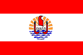
Flag of French Polynesia,
ratio = 2:3,
Source, by:
Wikipedia (D)


1975–1984
unofficial local flag,
ratio = 2:3,
Source, by: World Statesmen

at times spread, but incorrect variant of the flag of French Polynesia
All French colonies had no own flag over a long period. It had to be hoisted the French tricolor. This in principle usual until today. The status of the colonies changed over the years. Some of them are now overseas departments, and thus a ultraperipheric part of France and of the EU; others are overseas communities, autonomous, and not a part of France or the EU. Overseas departments belong – in contrast to the departments of the motherland – to no administrative region of France, they are a separate region. French Polynesia was the first, and initially the only French colony and overseas community who was allowed to have its own official flag since 1984. The flag, however, can only be hoisted on land, and just next to the French flag. It is a red-white-red bicolour, the white centre-stripe is larger and shows an emblem, the symbol of French Polynesia. The flag remembers deliberately to the flag of Tahiti. There live 60% of the population, and Tahiti was the most powerful kingdom in the region, that dominated almost all archipelagos in the region between the beginning and the middle of the 19th century. The entire region of French Polynesia is unofficially known as "Tahiti and its islands".
Source:
Wikipedia (D),
FOTW

Coat of arms of French Polynesia,
Source, by: Wikipedia (D)
The emblem of French Polynesia shows a stylized Polynesian canoe with red sails. five stylized human figures appear between the hulls. They represent the five archipelagos of the country. The canoe moves towards the sun, which stands for life. The sea is represented by five blue wavy lines.
Source:
Wikipedia (D),
FOTW
Position:
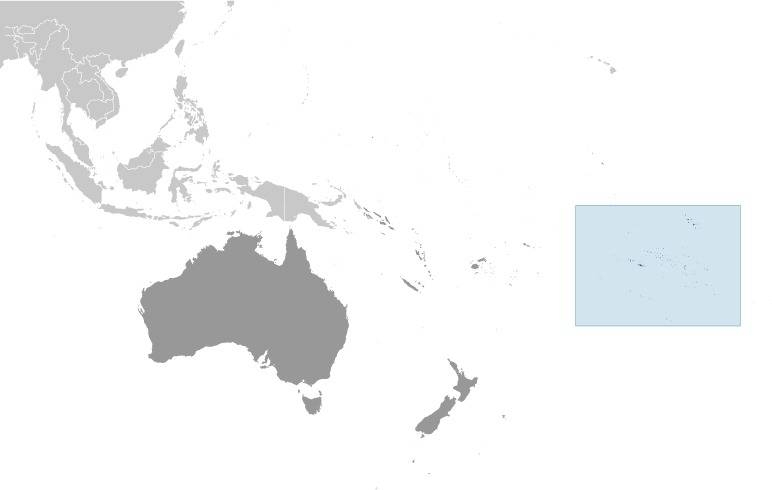
Source: CIA World Factbook
Map of the Country:
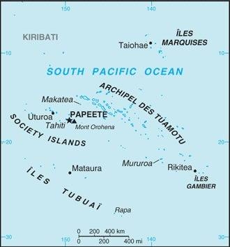
Source: CIA World Factbook
Subdivisions:
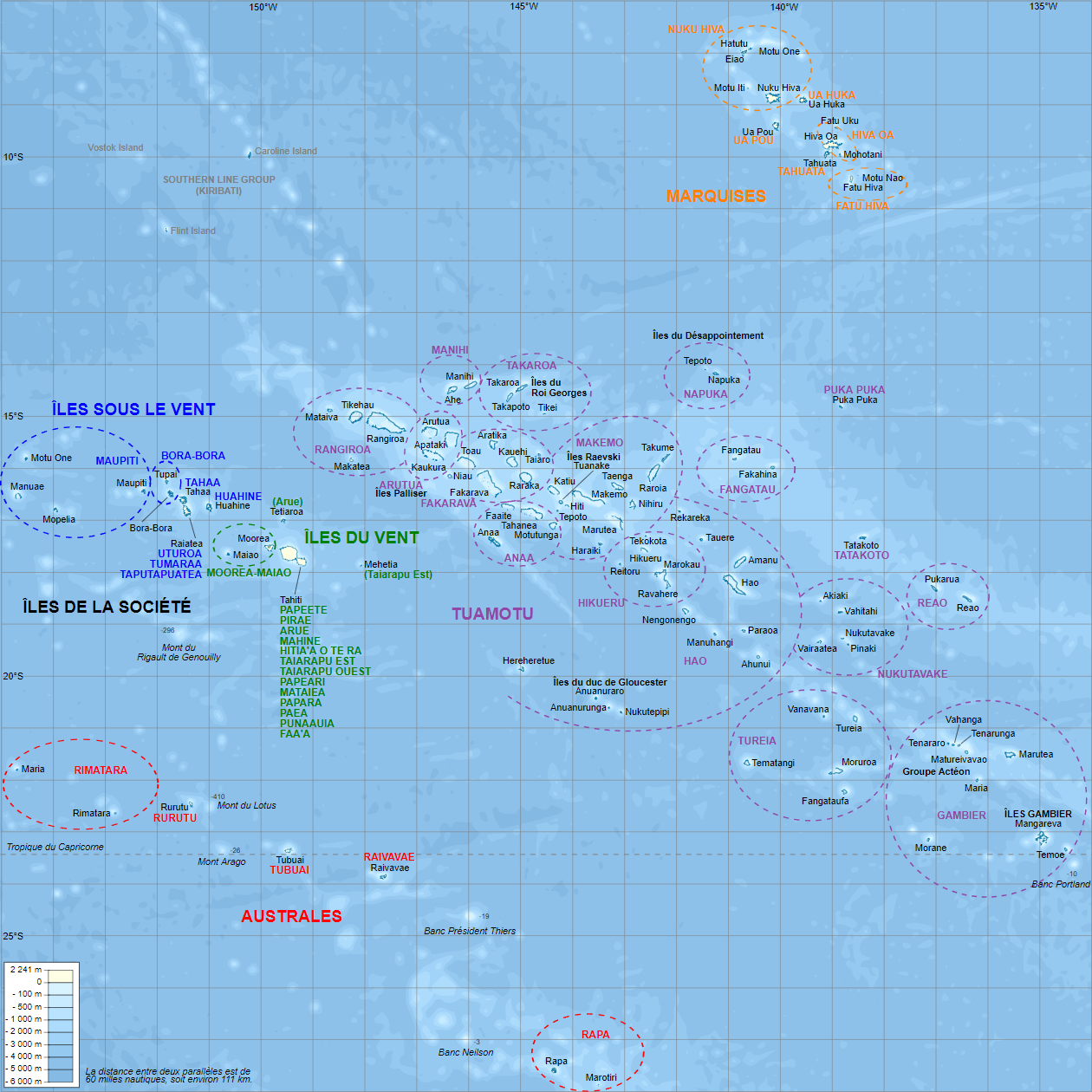
Landkarte/map, Source: By L. Claudel (Sardon - fr:Sardon)
[GFDL or CC BY-SA 3.0], via Wikimedia Commons,
click to enlarge |
Area: 1.609 square miles
Subdivisions:
Windward Islands (Îles du Vent), part of Society Islands, 461 sq.mi., 207.333 inh., Capital: Papeete
Leeward Islands (Îles Sous-le-Vent), part of Society Islands, 155 sq.mi., 35.393 inh., Capital: Uturoa
Austral Islands (Îles Australes, Îles Tubuai), inkl. Bass Islands, 57 sq.mi., 6.965 inh., Capital: Mataura
Tuamotu-Gambier Islands (Îles Tuamotu-Gambier), 280 sq.mi., 16.881 inh., Capital: Rangiroa
Marquesas Islands (Îles Marquises), 405 sq.mi., 9.346 inh., Capital: Taiohae
Source: Wikipedia (EN)
Inhabitants: 283.007 (2017), thereof 78% Polynesians, 12% Chinese, 10% Europeans
Religions: 54% Protestant, 30% Roman Catholic, 6% Non-Religious
Density of Population: 176 inh./sq.mi.
Capital: Papeete, 26.926 inh. (2017)
official Language: French
other Languages: Polynesian dialects
Currency: CFP-Franc (CFPF) = 100 Centimes,
CFPF = "Franc des Colonies Françaises du Pacifique"
Time Zone: GMT –9 to –10 h
Source: (1)Wikipedia (D),
(2)Wikipedia (D)
500 B.C. · beginning polynesian settlement
1521 · Magalhães discovers the Touamotu-Archipelago
1595 · Mendaña and Quiros discover the Marquesas-Islands
1605 · Quiros and Torres explore the Gambier and Society Islands
1616 · La Maire and Shouten explore the Society Islands
1768 · Bougainville explores the Society Islands
1773-1777 · James Cook explores Polynesia
1842 · France declares Tahiti to a French protectorate
1847 · establishment of the French administration in Tahiti, the to United Kingdom friendly archipelagos of Bora-Bora, Raiatea and Huahine become independent kingdoms
1880 · France annexes Tahiti, the islands (Tahiti, Mehetia, Moorea, Tetiaroa) become a French colony
1880 · France declares Raiatea to a French protectorate
1888 · France annexes Bora-Bora, the islands (Bora-Bora, Tupai, Maupiti, Maupihaa, Manuae, Motu One) become a French colony
1888 · France declares Huahine to a French protectorate
1888 · France annexes Raiatea, the islands (Raiatea and Tahaa) become a French colony
1897 · France annexes Huahine, the islands (Huahine and Maiao) become a French colony
1903 · establishing of a unified French colonial administration for the Society Islands, Marquesas Islands, Tuamotu Islands, Gambier Islands and Austral Islands under the name "French Polynesia"
1958 · Overseas Territory
1966-1995 · nuclear tests on Mururoa Atoll
1968 · test of a hydrogen bomb above Fangataufa Atoll
1977 · France grants limited autonomy
1984 · extension of the autonomy rights
1990 · extension of the autonomy rights
2004 · New Statute of Autonomy, French Polynesia is transformed from an Overseas Territory into an Overseas Country / Overseas Community, only foreign policy, justice, defence, internal security and monetary affairs remain the responsibility of France
Source:
Wikipedia (D),
FOTW
The term "Polynesia" comes from the 18th century and is a construct of two Greek words: "poly" (many) and "nesoi" (islands), and refers to the more than 1.000 islands scattered over the central and southern Pacific Ocean.
Source:
CIA World Factbook